Dr. Ming Ye
Ph.D., University of Arizona
Professor
Department of Earth, Ocean, and Atmospheric Science (EOAS)Office:
Department of Scientific Computing (SC)
Office:
Phone:
Fax:
Email: mye@fsu.edu


Annoucement:
ArcNLET version 3.0 for ArcGIS 10.6 is available for download.
ArcNLET version 3.0 for ArcGIS 10.2, 10.3, and 10.4 is available for download. This version of ArcNLET simulate reactive transport of both ammonium and nitrate.
ArcNLET version 2.01 for ArcGIS 10.2 and 10.3 is available for download
ArcNLET version 2.01 for ArcGIS 10.0 and 10.1 is available for download
ArcNLET version 2.0 for ArcGIS 10 is available for download
The new version includes a new function to quantify uncertainty in ArcNLET-estimated nitrate load.ArcNLET version 1.1 for ArcGIS 10.1 is available for download
ArcNLET version 1.1 for ArcGIS 9.3 and 10.0 are available for download
Documentation of sensitivity analysis and uncertainty assessment using ArcNLET is available for download
Media coverage on our project at FSU News
Esri Hydro Blog of ArcNLET
. ArcNLETArcGIS-Based Nitrate Load Estimation Toolkit
Developer: J. Fernando Rios, Ming Ye, Liying Wang, and Paul Z. Lee
Contact: Use the form below under Support/Comments or email directly to Professor Ming Ye at mye@fsu.edu
Funding Sources: Florida Department of Environmental Protection (FDEP)
and Institute for Energy Systems, Economics and Sustainability (IESES)
Description
Estimating groundwater nitrate fate and transport is an
important task in water resources and environmental management because
excess nitrate loads may have negative impacts on human and
environmental health. With the joint support of FDEP and IESES, a
simplified nitrate transport model was developed. Computational implementation
of the model leads to a geographic information system (GIS)-based screening tool, whose purpose
is to estimate nitrate loads to surface water bodies from onsite
wastewater-treatment systems (OWTS). Key features of this software are
the reduced data demands due to the use of a simplified model, as well
as ease of use compared to traditional groundwater flow and transport
models, achieved by embedding the model within ArcGIS. The simplified
conceptual model consists of a simplified groundwater flow model in the
surficial aquifer, and a simplified transport model that makes use of
an analytical solution to the advection-dispersion equation, used for
determining nitrate fate and transport. Denitrification is modeled
using first order decay in the analytical solution with the decay
constant. The
groundwater flow model uses readily available topographic data to
approximate the hydraulic gradient, which is then used to calculate
seepage velocity magnitude and direction. Load calculations are carried
out using a mass balance approach where the system is considered to be
in the steady state.
Download
The software is available for free download by completing the form below. By filling in this
information, it helps us know who is interested in the software!
ArcNLET requires ArcGIS 9.3, 9.3.1 10.0, or 10.1 with Spatial Analyst.
The software documentation is not included in the ArcNLET download package. Instead it is provided here as a separate download (in PDF format)Documentation of ArcNLET 1.0 and 1.1
| User's Manual: | Software installation, input file preparation, and execution. |
| Technical Manual: | Conceptual models and software design, development, verification and validation |
| Application Manual: | Case study at the Eggleston Heights and Julington Creek neighborhoods in Jacksonville, FL |
| Sensitivity and Uncertainty: | Sensitivity analysis and uncertainty assessment using ArcNLET have been conducted for several neighborhoods at Jacksonville, FL |
| User's Manual: | Software installation, input file preparation, and execution. |
Sample Data of ArcNLET 1.0 and 1.1
In order to follow the tutorial in the User's manual, the data required is provided here
lakeshore_example.zip (11 MB)
Sample Data of ArcNLET 2.0
In order to follow the tutorial in the User's manual, the data required is provided here
julingtonclip_example.zip (11 MB)
Disclaimer
THE SOFTWARE IS PROVIDED "AS IS", WITHOUT WARRANTY OF ANY KIND, EXPRESS OR IMPLIED, INCLUDING BUT NOT LIMITED TO THE WARRANTIES OF MERCHANTABILITY, FITNESS FOR A PARTICULAR PURPOSE AND NONINFRINGEMENT. IN NO EVENT SHALL THE CONTRIBUTORS, COPYRIGHT HOLDERS OR FLORIDA STATE UNIVERSITY OR ITS EMPLOYEES BE LIABLE FOR ANY CLAIM, DAMAGES OR OTHER LIABILITY, WHETHER IN AN ACTION OF CONTRACT, TORT OR OTHERWISE, ARISING FROM, OUT OF OR IN CONNECTION WITH THE SOFTWARE OR THE USE OR OTHER DEALINGS WITH THE SOFTWARE.<>
Licensing

ArcNLET by J. Fernando Rios, Ming Ye, Liying Wang, and Paul Z. Lee is licensed under a Creative Commons Attribution-NoDerivs 3.0 Unported
License.
Based
on a work supported by the FDEP and IESES. This license allows for
redistribution, commercial and non-commercial, as long as it is passed
along unchanged and in whole, with credit to us. The FDEP shall have a
royalty-free nonexclusive
and irrevocable right to reproduce, publish, or otherwise use the work
for governmental purpose.
Software Training Workshops
- The first software training workshop was offered in July 8, 2011. Below are the materials used for the workshop:
Please complete the following form to submit a bug report or to provide comments. Be sure to include as much information as possible (including the program log)! History
Software version history (* = current release):
| Release | Notes |
|---|---|
| (2013-09-19) v2.01 | -ArcNLET v2.01 for ArcGIS 10.0 Changes and New Features |
| (2013-07-24) v2.0 | -ArcNLET v2.0 for ArcGIS 10.0 Changes and New Features |
| (2013-06-10) v1.1 | -ArcNLET v1.1 for ArcGIS 10.1 Changes and New Features | (2011-08-11) v1.1 | -Changes and New Features |
| (2011-07-01) v1.0 beta | -Beta release 3 |
| (2011-06-21) v1.0 beta | -Beta release 2 |
| (2011-06-16) v1.0 beta | -Beta release 1 |
Screenshots
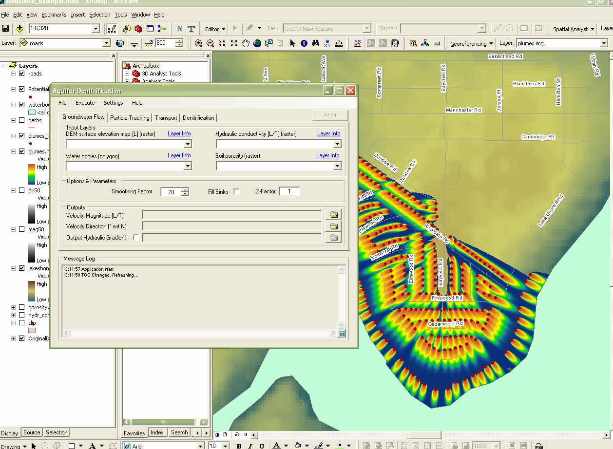 Main Window Overview |
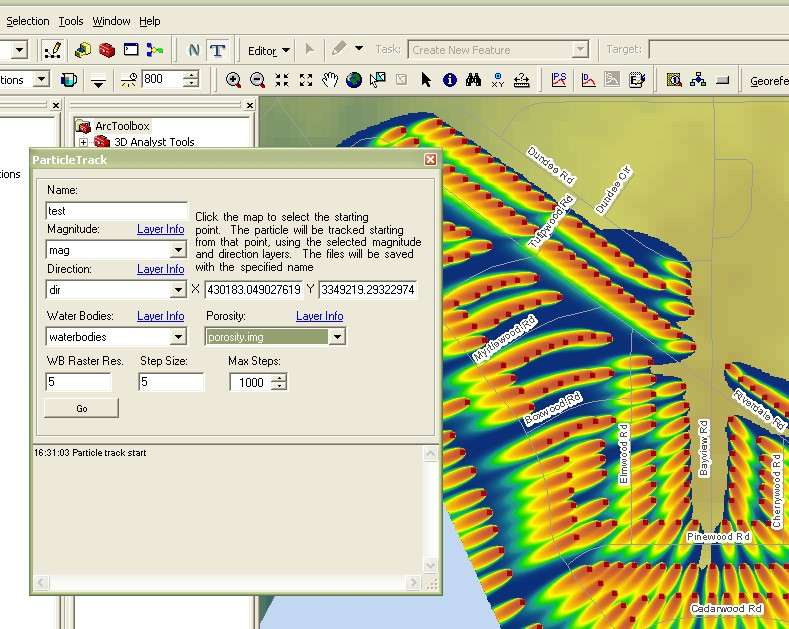 Interactive Particle Tracking Overview |
 Groundwater Flow Module |
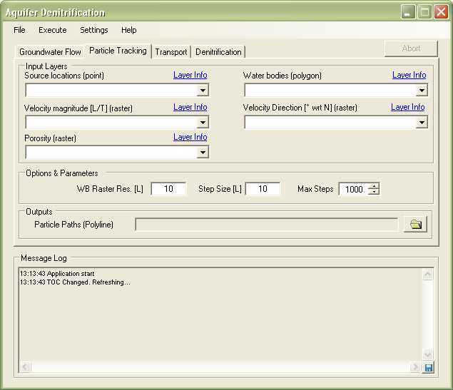 Particle Tracking Module |
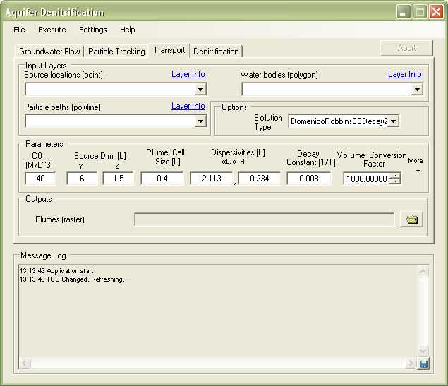 Transport Module |
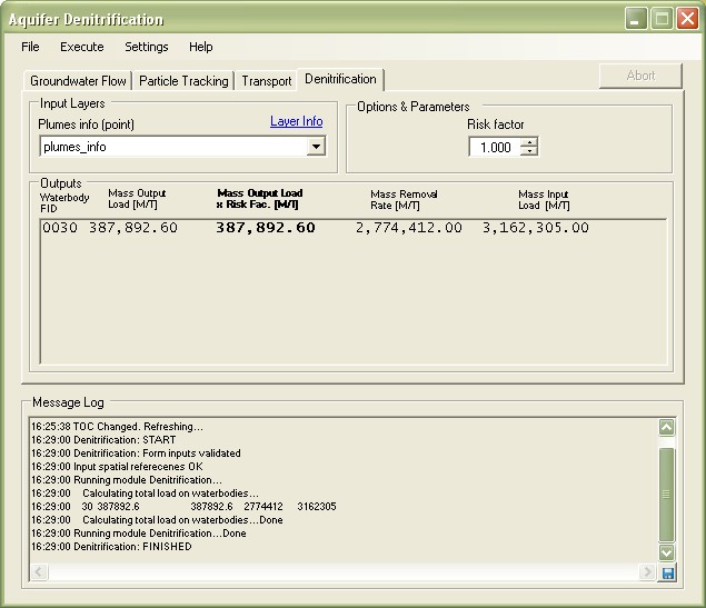 Nitrate Load Estimation Module |